


48 Days on the Road
We are entering big wave territory, so big that they named the highway going along the coast of Taranaki Surf Highway 45. But we aren’t road tripping down the highway for surf… No… There’s more to this scenic route. So, with our 15 Places to Stop at on Taranaki’s Surf Highway 45 article on hand, we pick a few of the sights that interest us the most, and we head on the road.
Get us to the beach!
It’s another day in Taradise (pun courtesy of Brett from Ducks and Drakes Hostel), and the sun is beaming down on us. We kind of get a little excited and get our beach visit done early in today’s trip. So 10 minutes out of New Plymouth, we are pulling up to Oakura Beach. This is a huge huge hhhhuuuggeeee black sand beach. We can’t see where it ends or begins. We can, however, see the outline of Paritutu Rock and the Sugar Loaf Islands, where we were yesterday, and only mystery awaits on the other end of the beach. After a stroll with the sun reflecting in the water and consistent waves rolling in, we get back on the road quickly so we can fit today’s itinerary in.
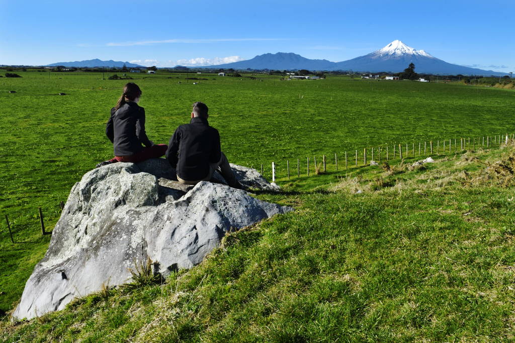
An epic view of mountain and sea
There are two things we are expecting from this trip: amazing views of the coast and amazing views of Mt Taranaki, which stands tall and unmissable in the centre of the region. On a day like today, the contract between blue skies, green hills and a white mountain just looks like something of dreams. We are in awe of this mountain. In terms of the coastal part of the Surf Highway, the highway only really provides access to other roads heading towards the coast. We are not literally driving on coastal cliff edges like we were on the Pacific Coast Highway in the Coromandel.
A lonely lighthouse
In the middle of the Surf Highway and the most western point of Taranaki is the Cape Egmont Lighthouse. We’ve seen some stunning photos on Instagram coming out of this place, so we have to go check it ourselves.
But wait! As soon as we leave the highway to turn onto the Cape Egmont Road, the mountain is looking freakin’ amazing in our rear view mirrors! We are pulling over (safely of course) and taking photos like crazy people… which we are.
There’s the lighthouse, sticking up high above the surrounding and unusual isolated green hills. All of these hills are ancient lahars created by Mt Taranaki’s volcanic activity. This really is a picture perfect spot and a prime example of how you could be one a mountain in a morning and in the sea by the afternoon. You have the best of both worlds here in Taranaki.

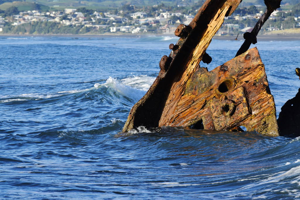
Shipwreck, ahoy!
After lunch on another sea cliff edge in Taranaki, we are going to make our way back down Surf Highway 45 and visit those spots we simply can’t miss. First up is the shipwreck of the SS Gairloch. At the southern end of Oakura Beach, we take an access road straight to its wreck site, Timaru Road. There’s a handful of surfers occupying the beach, but the skeleton of an old ship can be seen isolated a short walk down the beach. You can tell that what little remains of the ship has been sitting here for centuries. Now, it is used by seabirds taking it in turns to sit on the SS Gairloch’s highest point. Nevertheless, it’s a cool piece of history to see – something that is quite uncommon in New Zealand considering the country is pretty young.
The perfect day to be looking at a rusty old ship
The most fascinating pa site in New Zealand (that we’ve seen so far)
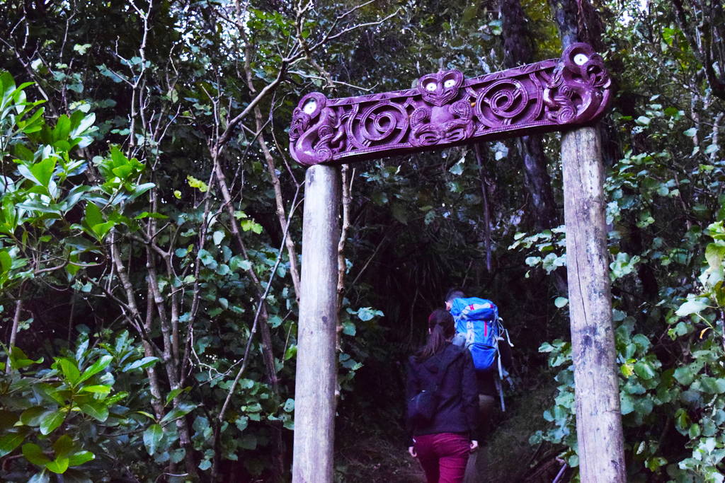
It has to be said, that the final historical site we visit today is the most fascinating to us. Next we are going to an old pa site. A pa is a fortified Maori village. Although there are many pa sites in New Zealand, so little evidence of them remain making it hard to imagine what they must have looked like. This is kind of what we are expecting with the pa site we are about to visit, but something tells us that we should go check it out anyway.
Te Koru Pa is one of the oldest pas in New Zealand, dating back to the 14th century. There’s a short walk to the reserve through farmland where Robin tries and fails to make friends with the cows. We’re opening gates and closing gates so the cattle doesn’t escape until we reach the entrance to the pa site, characterised by a carved archway and an information board giving an artist’s impression of the pa along with some pretty interesting facts. Let’s head into the pa!
Remains of Maori history
Te Koru is on a hill thick with native forest. There are several walkways around the pa to lookouts and terraces. Terraces were a major defence mechanism, usually topped with stakes to stop enemies from climbing them. When we see the stone remains of some terraces, we get so excited! We have never seen any remains from the early Maori settlers (besides in museums)! There is an information board in front of the remains giving a depiction of what the terrace used to look like. Further down the path, we find more remains, this time a ditch in the ground rimmed with stone where Maori used to make a fire. The information board tells us this would be the centre of a living quarters that once stood here.
More stone terraces can be seen throughout the pa, and we are buzzing that we’ve had a chance to see something unique, especially because Te Koru Pa was one of very few pas made with stone.
Dusk has fallen, making an orange and blue hue on the horizon for the rest of the short journey back into New Plymouth. We arrive back at the hostel just in time to have dinner with Waiji, who is WWOOFing at Ducks and Drakes.
Tomorrow, we are heading north up the coast in search for the Elephant Rock. See you then!
Have a look around one of New Zealand
Theta 360 Loading...
Want more?
We are here to serve! Check out these articles on how to backpack around New Zealand like a boss!
- 15 Places to Stop at on Taranaki’s Surf Highway 45
- 10 Loneliest Lighthouses in New Zealand
- Everything You Need to Know About WWOOFing in New Zealand
We also have heaps of travel tips coming at you every day on Facebook.
See you tomorrow, travel buddies!


![15 Best Backpacker Hostels in Tongariro National Park 🎒 [2024]](data:image/svg+xml;nitro-empty-id=MjE4OToxNDYx-1;base64,PHN2ZyB2aWV3Qm94PSIwIDAgOTAwIDUwNiIgd2lkdGg9IjkwMCIgaGVpZ2h0PSI1MDYiIHhtbG5zPSJodHRwOi8vd3d3LnczLm9yZy8yMDAwL3N2ZyI+PC9zdmc+)