


62 Days on the Road
It’s decision time. The forecast for Ohakune and Mt Ruapehu is looking pretty sh*t for the whole week, so we could sit around waiting for a window of opportunity to do some skiing or mountain biking, or we can just make Ohakune a pit stop on our way back during the summer months. We’ll go for the latter and make our way to Taihape, but not before leaving without a lower mountain hike.
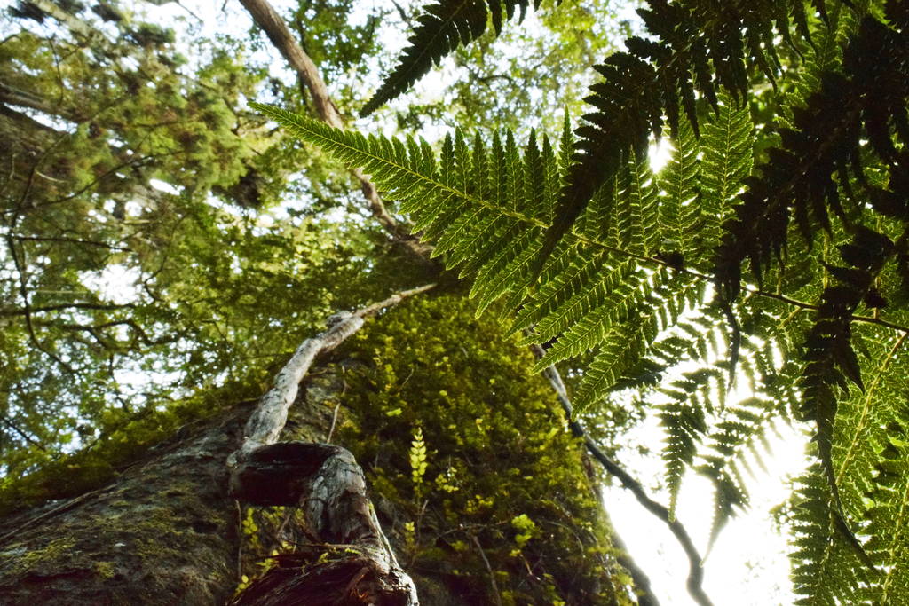
The Mangawhero Forest Track
At the entrance to Mountain Road is the Mangawhero Forest Loop Track which is a forest walk sheltering us from the rough elements. And because we don’t have snow chains or a 4×4 vehicle, we can’t get further up the icy mountain road to visit the Mangawhero Falls (a Lord of the Rings location). This Mangawhero Forest Loop Track is in a perfect location for a hike on a day like today.
Every walk we do in New Zealand always surprises us. Although the Mangawhero Forest Loop Track is reminiscent of the Enchanted Track we did on Mt Taranaki, it has some crazy-looking trees that we are in awe of. Huge straight-shooting trees have coiled their way up to sunlight with trunks the size of a car. Other trees have died leaving holes right through the trunks. This walk is also hugely varied compared to the Enchanted Track on Mt Taranaki. To compliment that, there are information signs for each type of tree or plant in the forest.


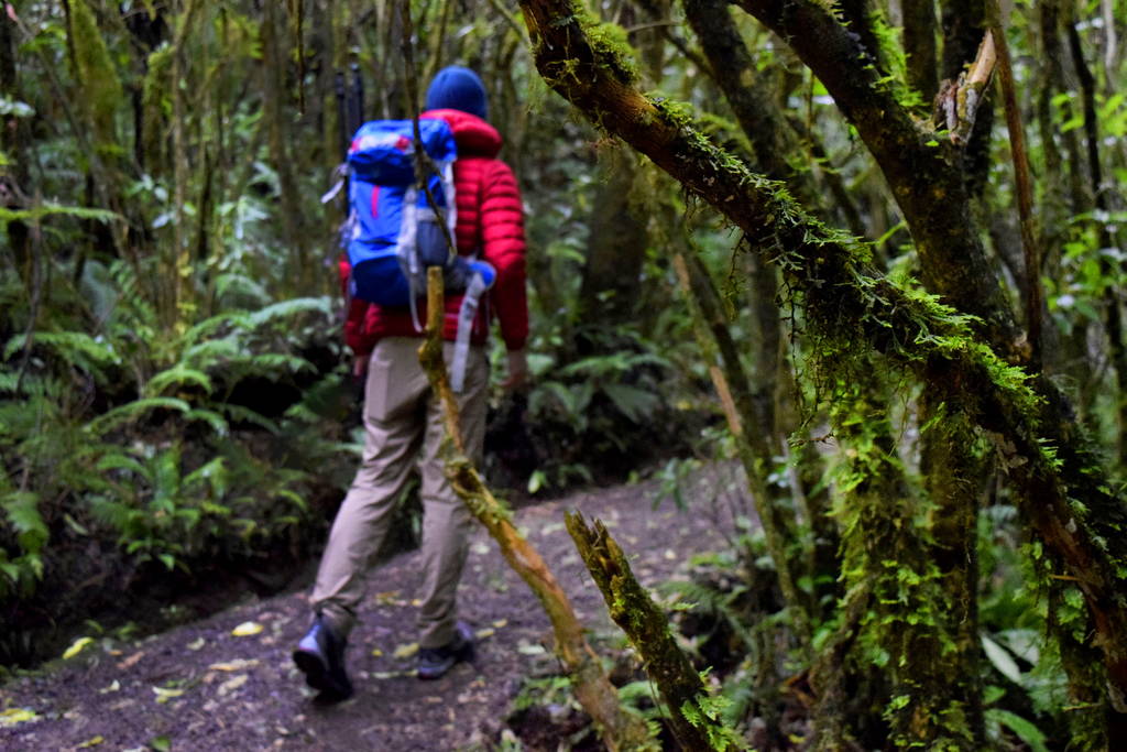
The crankin’ Mangawhero River
Where some of these larger trees have fallen down, there are sometimes these small wooden boxes with the words: Home for Wetas. Wetas are a native insect that can grow to huge sizes. However, when we open the weta’s home, there is nothing to see inside this time. Bad times.
Where the loop track goes deep into the forest, it soon makes its way back the Mangawhero River again, a river that is crankin’ (a term we are still loving from our guide T when we went canyoning in the Coromandel) from all the rainfall. Yet, it still looks amazing in the middle of this greener than green forest, washing over rocks, creating rapids, or navigating past moss-covered boulders.
The slowest road crossing of our lives
Halfway through the walk, there is a Department of Conservation (DoC) sign directed us to cross the mountain road to the other side where the walk continues. On one side of the road it says: 30 minutes remaining of the track. When we cross the road, it says: 25 minutes remaining. Now, we are not that slow at crossing the road, nor are the roads particularly wide in New Zealand. The thing with DoC signs is that you have to take them with a pinch of salt. Although they are great at pointing you in the right direction, their timing is something left to be desired. We have been known to even walk back in time on DoC walks.
The rest of the walk is much the same as the first half, so we take the time to power walk this well-maintained track and just soak in the forest walk instead of stopping every two seconds to take photos.

The Tangiwai Disaster Memorial
Back at the van, it’s time to leave Ohakune. We’ll be back in the Carrot Capital Where Adventures Begin, but our adventure must move on as we head south! About 15-minutes out of Ohakune is a memorial off the main State Highway 43 to the victims of the Tangiwai Disaster. We pull in to have a look. There’s information boards to show what happened on Christmas Eve 1953, when the Crater Lake of Mt Ruapehu sent a lahar of mud, rocks, ice and water down the Whangaehu River. This struck the Tangiwai railway bridge making it unstable for the crossing of an express train from Wellington to Auckland with 285 passengers and crew. The express train plunged into the river taking the lives of 151 people. At the time, it was one of the world’s worst rail disasters. Even as we are having a look at the information board under the shelter of the p*ssing down rain, about three or four cars come and go for a look at the memorial. At the time of the disaster, the population of New Zealand was so small that it was likely everyone knew someone in that train accident.
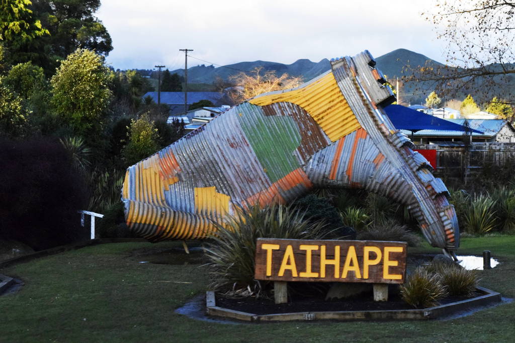
Welcome to the Gumboot Capital of New Zealand!
Back on the road, we are only about 30-minutes drive from our overnight stop, Taihape. This is a town everyone will find themselves passing through on State Highway 1, the main route between the two city giants of the North Island, Auckland and Wellington. Incidentally, Taihape is the Gumboot Capital of New Zealand! This is marked with a huge sculpture of a floppy gumboot at the town’s entrance.
Our accommodation tonight is the Rusty Nails Backpackers, which at first we are confused as to why this backpackers is so far out of the main town. (By so far, it’s about 5 minutes up a hill road). But as we get out of our van as the sun is going down, we can see why. The golden sun is shining off the rolling hills. The Rusty Nails Backpackers has a picture perfect view over Taihape.
Tonight, we are cooking up some vegetable fried rice and planning what the hell we can do tomorrow. See you then!
Check out the Mangawhero Forest!
Theta 360 Loading...
Want more?
Then maybe you should feast your eyes on these articles:
- Manawatu – Guide for Backpackers
- Ruapehu – Guide for Backpackers
- The Famous Lord of the Rings Filming Locations in Ruapehu
We post daily New Zealand travel tips on Facebook and daily New Zealand earth porn on Instagram.
See you tomorrow!


![15 Best Backpacker Hostels in Tongariro National Park 🎒 [2024]](data:image/svg+xml;nitro-empty-id=MjE3MDoxNDYx-1;base64,PHN2ZyB2aWV3Qm94PSIwIDAgOTAwIDUwNiIgd2lkdGg9IjkwMCIgaGVpZ2h0PSI1MDYiIHhtbG5zPSJodHRwOi8vd3d3LnczLm9yZy8yMDAwL3N2ZyI+PC9zdmc+)
![10 Best Hostels in National Park Village & Whakapapa 🎒 [2024]](data:image/svg+xml;nitro-empty-id=MjE5Nzo5NzI=-1;base64,PHN2ZyB2aWV3Qm94PSIwIDAgOTAwIDYwMCIgd2lkdGg9IjkwMCIgaGVpZ2h0PSI2MDAiIHhtbG5zPSJodHRwOi8vd3d3LnczLm9yZy8yMDAwL3N2ZyI+PC9zdmc+)